

Request a Sample Itinerary
We will send you a sample itinerary which you can further customize as you wish. We will never sell or share your email address with anyone else.
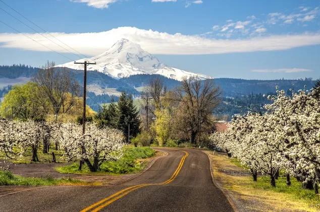
Cycling Oregon: Volcanoes, Vineyards, and the Best Beer Town in America
Some cycling destinations require a plane ticket and a passport. Oregon just requires curiosity — and it rewards that curiosity with a landscape that swings from snow-capped volcano to rolling wine country to one of the most dramatic river gorges in North America, often within a single day's ride. This is a state that punches well above its weight for cyclists, offering rolling vineyards, towering hop trestles, thundering waterfalls, and small towns with an outsized welcome, all without leaving the Pacific Northwest.
A cycling tour through Oregon typically explores two distinct regions: the Willamette Valley, source of some of the world's finest Pinot Noir, and Mount Hood together with the Columbia River Gorge, where cyclists ride beneath a snow-capped volcano that never quite leaves the horizon. Longer tours combine both; shorter ones may focus on just one.
Two Landscapes, One Unforgettable Backdrop
Mount Hood and the Columbia River Gorge deliver some of the most spectacular riding anywhere in the country — rolling wheat farms, bucolic fruit orchards, and a descent down the Columbia River Gorge itself, which runs between the snow-capped peaks of Mount Hood and Mount Adams, stretching more than 80 miles long and up to 4,000 feet deep. The Columbia River, rising in the Rocky Mountains of Canada, is the fourth-largest river in the United States, and much of the Gorge riding follows the Historic Columbia River Highway — a route Bicycling Magazine has called one of the best rides in America.
The Willamette Valley, meanwhile, produces some of the country's finest wine while somehow attracting far less attention than its Californian rivals in Napa and Sonoma. Riders here cover mile after mile of quiet rural lanes, past a patchwork of vineyards, hop farms, orchards, and the wheat fields of the French Prairie, linking small, unpretentious towns known for a genuinely warm welcome. Bounded by the Oregon Coast Range to the west, the Cascade Range to the east, and the Calapooya Mountains to the south, the valley's remarkable agricultural richness traces back to the Missoula Floods — a series of catastrophic ice-age floods roughly 15,000 to 13,000 years ago, triggered when a massive glacial lake in present-day Montana repeatedly broke through its ice dam, sending torrents of water surging across Washington, Oregon, and Idaho and leaving behind rich alluvial soil in their wake.
Climate Built for Summer Riding
The best months for cycling in Oregon run from June through September, when temperatures turn pleasantly warm and rainfall risk drops significantly. Spring and fall remain good options too, though riders should be prepared for cooler temperatures and a higher chance of rain. Winter touring here isn't recommended.
A History Written by Rivers and Wagon Trails
The Columbia River Gorge has been home to people for more than 13,000 years, with the region's first residents believed to have crossed the Bering Land Bridge from Asia to Alaska sometime between 20,000 and 15,000 years ago. Native American tribes including the Chinook, Klickitat, and Wasco peoples relied on the Columbia's resources for trade and sustenance long before European contact. In 1775, Spanish explorer Bruno de Heceta became one of the first Europeans to chart Oregon's Pacific coast, naming the Columbia River in the process, though it was the Lewis and Clark Expedition — reaching the mouth of the Columbia in 1805 — that truly marked the beginning of American exploration and settlement in the region.
The following decades brought rapid change. John Jacob Astor established Fort Astoria in 1811, the first American settlement on the West Coast, kickstarting the fur trade. The 1846 Oregon Treaty settled the U.S.-British border at the 49th parallel, and by 1847 the Oregon Trail had reached its peak, delivering thousands of settlers westward. The 1850s brought the formal establishment of Oregon Territory and the growth of wheat, hops, and timber as key industries, and by the 1860s, a new railway connecting Portland to the Willamette Valley had turned Oregon into a genuine commercial hub. Oregon's first wineries appeared in the Willamette Valley in 1889, planting the seeds — quite literally — for what would eventually become one of the world's great wine regions. After a 20th century shaped by resource industries, the Great Depression, and World War II, Oregon's outdoor recreation identity began taking shape in the 1960s, and its wine industry has continued expanding ever since, turning the state into a genuine destination for eco-tourism and cycling.
A Native American Legend Behind the Landscape
Long before Lewis and Clark, the Klickitat people told a story explaining the dramatic peaks that still frame every ride through the Gorge. According to the legend, the chief of all the gods, Tyhee Saghalie, traveled down the Columbia River with his two sons, Pahto and Wy'east, in search of a place to settle. Finding a beautiful stretch of land near what's now The Dalles, the brothers quarreled over it, so their father shot two arrows from his bow — one north, one south — sending each son to settle where his arrow landed. Saghalie built a great natural bridge, later known as the Bridge of the Gods, so the family could reunite periodically.
When both brothers fell in love with the same maiden, Loowit, and fought bitterly over her, the earth shook so violently that the bridge collapsed into the river, creating the Cascade Rapids. As punishment, Saghalie transformed each of the lovers into a mountain: Wy'east, head lifted in pride, became Mount Hood; Pahto, bent toward his fallen love, became Mount Adams; and Loowit became Mount St. Helens, known to the Klickitats as Louwala-Clough, or "smoking mountain." Riders passing over the modern Bridge of the Gods between Stevenson and Troutdale are, in fact, crossing near the site of a real geological event — the original bridge was a natural dam formed by a massive landslide around 1450 CE, later breached by the river to form the rapids the legend describes.
Following Lewis and Clark — and the Oregon Trail
The Lewis and Clark Expedition, commissioned by President Thomas Jefferson shortly after the Louisiana Purchase, departed near St. Louis in May 1804 under Captain Meriwether Lewis and Second Lieutenant William Clark, tasked with mapping a practical route to the Pacific and establishing an American presence before European rivals could claim the territory. Their final westward push followed the Columbia River past what are now The Dalles, Hood River, and Portland, reaching the Pacific Ocean in November 1805 — sighting Mount Hood along the way, which told them they were close. The expedition's decision to relocate camp involved a noteworthy historical footnote: because Sacagawea and Clark's enslaved companion York were both allowed to vote on where to settle, it may have been the first time in American history that a woman and an enslaved person participated in a democratic decision.
Four decades later, the Barlow Road — followed today by riders traveling from Sandy to Welches — was built in 1846 as the final overland segment of the Oregon Trail, allowing covered wagons to cross the Cascades rather than risk the treacherous Columbia River. The terrain around Mount Hood made this stretch the most harrowing 100 miles of the entire 2,000-mile trail, with wagons sometimes lowered down muddy slopes by ropes wrapped around trees. Despite the difficulty, roughly three-quarters of pioneers entering the Willamette Valley used this route. Not far along it sits Government Camp — a small ski town today, and once the site of a genuine tragedy in 1849, when a military wagon train abandoned 45 wagons after dozens of mules starved to death along the way.
Above Government Camp sits Timberline Lodge, dedicated by President Franklin D. Roosevelt in 1937 as a Works Progress Administration project during the Great Depression. Now a National Historic Landmark built from rustic stone and massive timber at 6,000 feet elevation, the lodge has also achieved a slightly different kind of fame: it served as the exterior of the Overlook Hotel in The Shining.
Climbing the Volcano Itself
Mount Hood, at 11,250 feet, is Oregon's highest peak, and its accessibility — a road climbs to 6,000 feet — makes it tempting to prepared and not-so-prepared climbers alike. It's often cited as the second-most-climbed glaciated peak in the world after Mount Fuji, drawing around 10,000 attempts each year, though sadly 130 climbers have died on its slopes, most often due to sudden, deceptive weather shifts rather than avalanches. Nearly all attempts happen between April and July, and Mount Hood's glaciers double as a summer training ground for the U.S. Ski Team, offering year-round skiing.
Eating and Drinking the Willamette Valley
Oregon's food scene draws on local meats — pork, beef, lamb, game — alongside excellent seafood like salmon, Dungeness crab, oysters, and halibut, plus an abundance of fruits and vegetables grown in the Willamette Valley's fertile soil. Farm-to-table dining defines much of the state's culinary identity, with restaurants leaning heavily on fresh, seasonal, and often organic sourcing, while farmers markets and food carts are a fixture of both Portland and its smaller surrounding towns.
Two crops in particular define the region's agricultural character: hops and hazelnuts. Hops are the flowering cones of a vigorous climbing plant, trained up trellises in fields called hop yards and harvested in late summer to flavor and stabilize beer — riders traveling from McMinnville to Silverton are especially likely to see them growing. Oregon grows over 99% of the hazelnuts produced in the United States, though the U.S. accounts for only about 4% of global production, trailing Turkey, Italy, and Spain. Hazelnuts, also known as filberts, show up throughout Oregon cooking and baking — and, of course, as the base ingredient in Nutella.
Portland, meanwhile, is routinely recognized as one of the best beer cities in America, home to hundreds of craft breweries producing everything from hop-forward IPAs to rich stouts and tart sours, many drawing directly on hops grown just down the road in the Willamette Valley.
But it's wine that truly defines the region's reputation. Oregon's cool climate and varied soils have made the Willamette Valley internationally famous for Pinot Noir — elegant, complex wines built around vibrant red fruit flavors like cherry and raspberry, layered with earthy undertones and subtle spice, that have become a genuine benchmark for the varietal worldwide. The valley also produces excellent Pinot Gris, prized for its crisp acidity and notes of pear and citrus; nuanced Chardonnay, particularly from the Yamhill-Carlton District and Dundee Hills; and increasingly well-regarded Riesling, ranging from bone-dry to sweet with characteristic floral, stone-fruit brightness.
Getting There
Tours typically start in Portland, most easily reached by flying into Portland International Airport (PDX). From there, Uber and Lyft operate throughout the area, taxis run $40 to $60 for the 20-to-30-minute ride downtown, and the MAX Light Rail connects the airport to central Portland in about 45 minutes for just $3 per person.
Why Oregon Rewards a Bicycle
What makes Oregon such a compelling place to ride is the sheer range packed into a relatively compact area — a snow-capped volcano visible from vineyard rows, a river gorge carved by ice-age floods, small towns built around genuine hospitality rather than tourist infrastructure. A car covers the miles between Mount Hood and the Willamette Valley easily enough. A bicycle earns each transition, riding through the hop yards, past the hazelnut orchards, and along quiet country lanes that somehow still feel like a well-kept secret, even in a state this widely loved.
The complete guidebook can be viewed here.

Ready to plan your tour?
Tell us where you want to go and how you want to ride. We'll send you an itinerary.